Canoochee River Fishing Spot
- Elevation: 69'
- Last Modified By: vinny60 on 09/08/09 01:29 PM
- Ask about Canoochee River in our Fishing Forums
Photos
Fish Species
Comments
-
Have you fished at Canoochee River? Be the first to comment on this fishing spot.
Canoochee River Description
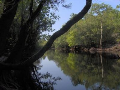
The Canoochee River is a river, about 100 mi (160 km) long, in southeastern Georgia in the United States. It is a tributary of the Ogeechee River, which flows to the Atlantic Ocean. The Canoochee River is formed about 12 mi (20 km) southeast of Swainsboro in southwestern Emanuel County by the confluence of Canoochee Creek and Little Canoochee Creek, and flows generally southeastwardly through or along the boundaries of Candler, Evans, Bryan, and Liberty Counties, through Fort Stewart. It joins the Ogeechee River from the west in Bryan County, 15 mi (24 km) south-southwest of Savannah. The Canoochee River is one of the most enchanting rivers in Georgia to canoe, with its tea-colored swamp water contrasting with white, sandy banks of the Coastal Plain. Beginning near Swainsboro in Emanuel County, the river flows 85 miles past extensive river swamps until it meets the Ogeechee River just north of Interstate 95 near Kings Ferry. Abundant wildlife species are found in the protective swamps, including many species of warblers, woodpeckers, owls, and occasional wading birds in the lower reaches. Turtles, snakes, and frogs thrive in the wet habitat, and alligators are seen peeking out of the water. The river's floodplain provides an important nursery for fish and in the main channel red breast, blue gill, crappie, sunfish, and channel catfish are common catches. The habitat provides refuge to many mammals such as raccoons, opossums, deer, and bobcats. The Canoochee has the reputation of supporting the most numerous and largest water snakes in Georgia. Wasp nests and spider webs hang from vegetation that borders the river. Ogeechee lime, cypress, black and sweet gum, willow, and swamp white oak grow along the banks. The Canoochee in its upper reaches north of the Evans County line is difficult if not impossible to run most of the year without encountering many deadfalls and requiring countless portages. Some put in at a park northwest of Claxton where GA 169 crosses the Canoochee for a run to US 301, the location of a small public park and a sandstone outcrop known as The Rocks. The next run is from this park to Rogers Bridge where Nevils-Daisy Road crosses. Some choose to continue on to US 280. At US 280, Lotts Creek adds its flow to the Canoochee, creating a much more canoeable stream, and a small park provides easy access. However, 4 miles south from 280, the river enters Fort Stewart Military Reservation and continuing on requires advance permission, or you risk having your canoe confiscated by military authorities. The total run from US 280 to Kings Ferry is 54 river miles, with four access points between for shorter trips. The base provost marshal's office has details of river access on the base.
The Canoochee River (pronounced kuh-NOO-chee) is a river, about 100 mi (160 km) long, in southeastern Georgia in the United States. It is a tributary of the Ogeechee River, which flows to the Atlantic Ocean.