Aucilla River Fishing Spot
- Elevation: 84'
- Last Modified By: vinny60 on 09/08/09 01:08 PM
- Ask about Aucilla River in our Fishing Forums
Photos
Fish Species
Comments
-
Have you fished at Aucilla River? Be the first to comment on this fishing spot.
Aucilla River Description
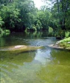
The Aucilla River arises close to Thomasville, Georgia and passes through the Big Bend region of Florida, emptying into the Gulf of Mexico at Apalachee Bay. The river is 75 mi (121 km) long and has a drainage basin of 747 square miles. The Wacissa River is a tributary. In Florida it forms the eastern border of Jefferson County, separating it from Madison County on the northern part, and from Taylor County to the south. The lower part of the river disappears underground and reappears several times, and is known as the Aucilla River Sinks. Wandering its way for seventy miles through swamps and hardwood hammocks this river somehow misses every major town or industry anywhere near its path. The Aucilla arrives at the Gulf as a tea colored river of medium size. The exact point of entry is the far eastern end of the St. Marks National Wildlife Refuge. The Aucilla forms part of the St. Marks eastern boundary right before it enters Apalachee Bay and the Gulf of Mexico. This is the part of the refuge that visitors to St. Marks rarely see. Fishing is what brings people to the Aucilla River but it is the sights and sounds of this wilderness that keep them coming back. Fortunately a bad day of angling is hard to have on this river. The Aucilla will almost always provide action even under the worst of conditions. On a good day the trout and redfish will wear you out before you wear them out. Leaving the fish while they're still biting may be hard to do but it's a great feeling.
The Aucilla River rises close to Thomasville, Georgia, USA, and passes through the Big Bend region of Florida, emptying into the Gulf of Mexico at Apalachee Bay. The river is 75 mi (121 km) long and has a drainage basin of 747 square miles. The Wacissa River is a tributary. In Florida, the Aucilla River forms the eastern border of Jefferson County, separating it from Madison County on the northern part, and from Taylor County to the south. The lower part of the river disappears underground and reappears several times, and is known as the Aucilla River Sinks. The Aucilla River is a rich source of late Pleistocene and early Holocene animal bones and human artifacts, and is the subject of the Aucilla River Prehistory Project, which includes the Page-Ladson prehistory site.