Apalachee River Fishing Spot
- Elevation: 434'
- Last Modified By: vinny60 on 09/08/09 01:05 PM
- Ask about Apalachee River in our Fishing Forums
Photos
Fish Species
Comments
-
Have you fished at Apalachee River? Be the first to comment on this fishing spot.
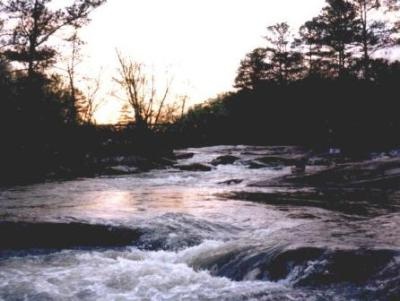
Apalachee River Description
The Apalachee reaches from Gwinnett County to Lake Oconee and is a major tributary of the Oconee River. Its character combines features of lowland swamps and streams of the Piedmont; at times it is a river, at times a virtually impassable swamp. The Apalachee River has something to offer just about anyone. The bass, crappie, white bass, catfish, and bream fishing can be spectacular (even more so once you've figured out the best stretches to fish)! The Apalachee also contains plenty of exciting rapids for whitewater enthusiasts and some swampy areas that I doubt have ever been seriously fished. The Apalachee can be a source of frustration, however, for those who attempt the wrong float. Read on and GRF will try to steer you to the type of water your looking for. The Apalachee starts in Gwinnett County and forms the border between Gwinnett, Walton, Barrow, Oconee, Greene, and Morgan Counties on it's journey to Lake Oconee, where it joins up with the Oconee River. While sections of the Apalachee north of GA 78 are canoeable, the river's small size, abundance of downed trees, and stretches of swamp make the upper river more suitable for wading. Between GA 78 and Lake Oconee, there are three dams that boaters should be aware of. One is just north of Snow's Mill Road and the other two are just above and just below GA 186 in the town of North High Shoals. All of these dams are a pain to portage, but nobody ever said this was going to be easy. The dams provide an opportunity for fishermen, however, because they back up the river's flow, creating hotspots for crappie and all the other species that prefer slacker water. There are also a few rapids that deserve special mention. The first is immediately below the dam located south of GA 186 at the town of North high Shoals. Don't even think of trying to run these rapids, because the last one is a doozy, a 15-foot slide down High Shoals Falls. The next big rapid occurs just upstream of Price Mill Road. Price Mill Shoals can reach Class III levels at high water and are pretty challenging any time. The last big shoals (The Rocks) occur just downstream of GA 441 and can also reach Class III. If you plan on fishing a section of the Apalachee that may require a portage or a good bit of maneuvering, take a canoe. A jon boat will work fine for most parts of the river. About two miles below the GA 441 bridge, the Apalachee gets really swampy and pretty much remains this way all the way to Lake Oconee. The river seems to keep splitting until you run out of water and it is common to spend more time carrying your boat through here than paddling it. Despite the hassle, some of this water is as bassy looking as you'll ever see! Yes, the Apalachee can be a real pain. The fishing can help ease some of that pain, however. The springtime crappie fishing on the Apalachee can be tough to beat, and the white bass and hybrid runs are underrated. People catch lots of bream and catfish and a friend and I once caught 14 keeper bass in two hours on a January float trip! The Apalachee generally runs about 45-60 feet wide and the water is normally a bit stained. The current is generally moderate but can vary from almost slack to faster than most people want to go. Development on the river downstream of GA 78 is sparse, but the river still has siltation problems due mainly to messy development in the Apalachee's upper reaches. I wouldn't recommend this river after a heavy rain.