Allatoona Lake Fishing Spot
- Public Fishing: Yes
- Max Depth: 145'
- Elevation: 847'
- Last Modified By: vinny60 on 09/08/09 12:58 PM
- Ask about Allatoona Lake in our Fishing Forums
Photos
Fish Species
Comments
-
Have you fished at Allatoona Lake? Be the first to comment on this fishing spot.
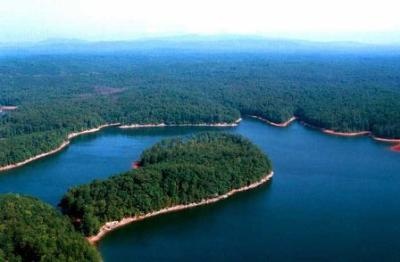
Allatoona Lake Description
Located only 30 miles from Atlanta, Georgia, Allatoona Lake is situated on the Etowah River, a tributary of the Coosa River. The serene lake and peaceful surroundings offer a respite from the rush of city living. Allatoona Lake is one of the most frequently visited Corps of Engineers lakes in the nation. More than 6 million visitors each year enjoy picnicking and swimming at our parks, camping, hunting, fishing, boating, and observing wildlife along the beautiful shoreline. Allatoona Dam impounds run-off water from 1,110 square miles into the Lake. For an unequalled view of the dam, we recommend a visit to the Project Management Office and Visitor's Center which is open Monday through Friday, 8:00 AM to 4:30 PM except holidays. There are numerous COE facilities and a Georgia State Park located around the lake to provide anglers with ramps, parking, and camping areas. The lake receives heavy use by boaters, skiers, and anglers due to its close proximity to Atlanta. Fishing early and late daylight hours, and at night, are effective ways to avoid the crowds and catch wary fish.The area offers fishermen numerous opportunities in terms of locations to fish and fish species. Convenient boat ramps, day use areas and campgrounds are situated around Allatoona. The Georgia Department of Natural Resources annually restock the lake through their fish stocking program. Along with native fish found in the lake, this provides a wide variety for anglers. Fish species include bass (largemouth, hybrid, stripped, spotted, and white), crappie, bream (bluegill, redbreast and redear sunfish), gar and catfish. There are boat launching ramps located in 27 public recreation areas around the lake. Ramps charge a $3 boat launch fee, day use areas charge a $4 facility use fee, or you may purchase a Corps of Engineers Annual Day Use Pass for $30. In addition, eight privately operated marinas provide fuel, storage, boat repairs, rentals, supplies, and other boater's needs.